Cmap Summer Project using the FPS
Project Title:
Where is the Bullying happening? Hotspots on the Playground
Created by: Libby McShinsky
Class: Canyons cmap 2012
Project Description
Community Issue or Problem Selected
-How project evolved?
Every student deserves to have a safe environment when going to school. Knowing where and what type of bullying that is happening in the school can help aids and teachers to know where to place people to help cut down these happenings.
Community Partner(s)
· 5th Grade and 6th grade students
· Teachers from the school
· Principal Valerie Shaw
Project Objectives
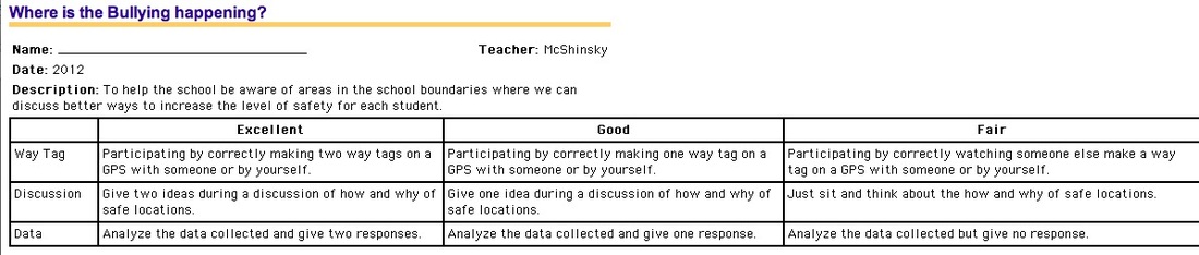
To help the school be aware of areas in the school boundaries where we can discuss betters to increase the level of safety for each student.
Utah Core Standards/Objectives
Health Level K-6
The students will adopt behaviors to maintain personal health and safety and develop appropriate strategies to resolve conflict.
Essential Question(s)
-Spatial Issue
How do keep ourselves safe when we are in public locations?
Why do we need to know that being safe is the same thing as being healthy?
Where are the safe places at the school?
Where are the hotspots of more dangerous places at school?
Assessments (rubrics, scoring guides)
Project Products
Students will create a map of the playground that is color-coded with hot spots of where the bullying events took place. Students will present finding evidence to the principal, teachers, and aids to be used for help with playground duty.
Project Timeline
(include a step by step Procedures)
Day 1:
Hook- Youtube Video - Bullying: Bridge to Terabithia
Train fifth grader students on GPS/GIS
Explain vision of project and what we want to accomplish. Help students to understand the importance of this project to the community.
Day 2:
Assign partners. Experiment with making waypoints on the GPS devices.
In pairs, students will walk the playground, gathering way points of where and how they were bullied or if they did an act of bullying.
Day 3:
With the help of an IT Tech students will create a map and import the data collected.
This day is important because it will be the first reaction to the data. A discussion of the “ how and why of safe locations.”
Day 4:
Analyze the data collected and give two responses. Assign to go home and discuss with parents the findings.
Day 5:
Invite the principal to the classroom and do a presentation on their findings. Present the principal with not only the map but also with suggestions from the analyzing and discussions.
Resources Needed
Skills Required
Project Team Member Roles
Teacher(s): Teach GPS skills or get someone who can
Students: Make waypoints, import data, make chart to analyze, discuss, and present findings
Partner(s): Teach and guide students through every step
Celebration/Presentation
ALOHA PARTY- Hawaiian party of safety for their
Area Locations Of Hazardous Areas- is now SAFE
Project Evaluation
Students present their data to the principal
Project Bibliography
Research on playground bullying
http://www.education.com/reference/article/promoting-social-skills-prevent-bullying/?page=4
Bullying: Bridge to Terabithia
Youtube Video http://www.youtube.com/watch?v=s29tejWB3n0
Plans for Future CMaP Activities
Beginning: One grade level
Future: Whole school- The class takes a buddy from another grade and works with them to way tag their grade level.
Advanced future: Compare different schools around the United States
Where is the Bullying happening? Hotspots on the Playground
Created by: Libby McShinsky
Class: Canyons cmap 2012
Project Description
- Two Part: Past Bullying Experience and Future Hotspots of Bullying
- Students will take the GPS units and waypoint each location where someone bullied them or they bullied someone else. They will write down what happened in that location.
- Students will categorize the types of incidence.
- Students will use GPS to collect data to locate, mark and map areas of incidence on the school boundaries.
- Students will gather data and make a map of the school boundaries color-coding the school.
Community Issue or Problem Selected
-How project evolved?
Every student deserves to have a safe environment when going to school. Knowing where and what type of bullying that is happening in the school can help aids and teachers to know where to place people to help cut down these happenings.
Community Partner(s)
· 5th Grade and 6th grade students
· Teachers from the school
· Principal Valerie Shaw
Project Objectives
To help the school be aware of areas in the school boundaries where we can discuss betters to increase the level of safety for each student.
Utah Core Standards/Objectives
Health Level K-6
The students will adopt behaviors to maintain personal health and safety and develop appropriate strategies to resolve conflict.
Essential Question(s)
-Spatial Issue
How do keep ourselves safe when we are in public locations?
Why do we need to know that being safe is the same thing as being healthy?
Where are the safe places at the school?
Where are the hotspots of more dangerous places at school?
Assessments (rubrics, scoring guides)
Project Products
Students will create a map of the playground that is color-coded with hot spots of where the bullying events took place. Students will present finding evidence to the principal, teachers, and aids to be used for help with playground duty.
Project Timeline
(include a step by step Procedures)
Day 1:
Hook- Youtube Video - Bullying: Bridge to Terabithia
Train fifth grader students on GPS/GIS
Explain vision of project and what we want to accomplish. Help students to understand the importance of this project to the community.
Day 2:
Assign partners. Experiment with making waypoints on the GPS devices.
In pairs, students will walk the playground, gathering way points of where and how they were bullied or if they did an act of bullying.
Day 3:
With the help of an IT Tech students will create a map and import the data collected.
This day is important because it will be the first reaction to the data. A discussion of the “ how and why of safe locations.”
Day 4:
Analyze the data collected and give two responses. Assign to go home and discuss with parents the findings.
Day 5:
Invite the principal to the classroom and do a presentation on their findings. Present the principal with not only the map but also with suggestions from the analyzing and discussions.
Resources Needed
- GPS Unit for each pair of Students.
- Data collection chart, clip board, and pencil.
- Arial picture of the school property.
- Computer installed with GIS Software
Skills Required
- Knowledge of GPS Device (basic waypoint skills)
- (IT Tech will help with compellation of the data gathered.)
- Basic Computer and software skills.
Project Team Member Roles
Teacher(s): Teach GPS skills or get someone who can
Students: Make waypoints, import data, make chart to analyze, discuss, and present findings
Partner(s): Teach and guide students through every step
Celebration/Presentation
ALOHA PARTY- Hawaiian party of safety for their
Area Locations Of Hazardous Areas- is now SAFE
Project Evaluation
Students present their data to the principal
Project Bibliography
Research on playground bullying
http://www.education.com/reference/article/promoting-social-skills-prevent-bullying/?page=4
Bullying: Bridge to Terabithia
Youtube Video http://www.youtube.com/watch?v=s29tejWB3n0
Plans for Future CMaP Activities
Beginning: One grade level
Future: Whole school- The class takes a buddy from another grade and works with them to way tag their grade level.
Advanced future: Compare different schools around the United States